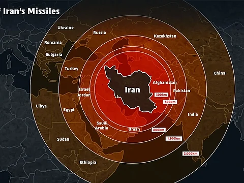

The Israeli Defence Forces (IDF) recently found themselves at the center of controversy after releasing a map that inaccurately depicted parts of Indian territory while illustrating the range of Iran’s missiles. The map, shared amid heightened tensions between Israel and Iran, showed Jammu and Kashmir as part of Pakistan and Northeast India as part of Nepal. This misrepresentation sparked immediate and widespread outrage across India, with many social media users and commentators demanding a correction and reiterating that these regions are integral parts of India’s sovereign territory.
The timing of the map’s release added to the sensitivity, as it coincided with Israel’s major military offensive targeting Iran’s nuclear and military infrastructure. The IDF’s message was intended to highlight the regional and global threat posed by Iran’s missile capabilities, emphasizing that the danger extended far beyond Israel’s borders. However, the inaccurate depiction of Indian borders overshadowed the intended message and threatened to strain diplomatic relations between India and Israel—two countries that share strong defense ties.
In response to the growing backlash, the IDF issued a public apology on X (formerly Twitter), clarifying that the map was meant as a general illustration of missile ranges and was not intended to represent precise national borders. “This post is an illustration of the region. This map fails to precisely depict borders. We apologise for any offence caused by this image,” the IDF stated. The Israeli Ambassador to India also acknowledged the error, describing the infographic as “bad unintended” and assuring that steps were being taken to address the issue.
This incident underscores the importance of accuracy in official communications, especially regarding sensitive geopolitical issues. While the IDF’s quick apology helped defuse tensions, the episode serves as a reminder of the diplomatic repercussions that can arise from even unintended misrepresentations on the global stage.