Team Herald
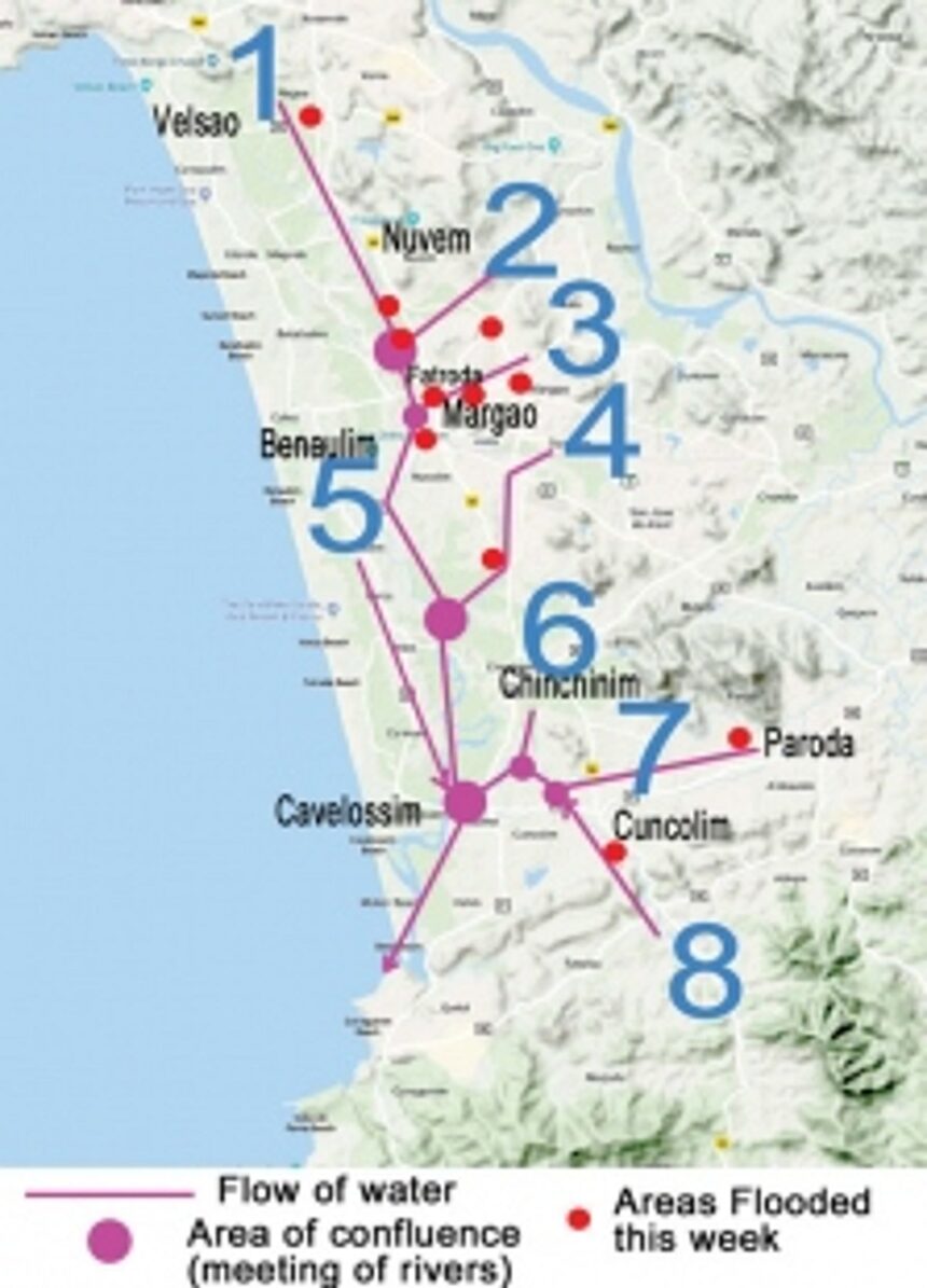
MARGAO: Salcete taluka is the basin of River Sal, which is a network of several tributaries that are, depending on the seasons, either fed by rainwater discharge or by springs located at the foot of the plateaus and hills surrounding Salcete from all side.
Understanding the flow of Sal is critical to planning the villages, to protect the locals from floods and to protect the environment.
The northernmost point of River Sal basin is at the foot of the Mormugao-Verna plateau. During dry seasons, the springs feed the streams in the area. During monsoon, the runoff from the plateau flow into the steams. They join together at various planes from Velsao to Nuvem. The interesting bit about this stretch is that there is a subterranean through flow of water underneath the paddy fields which is why the ponds in this area along the Utorda Velsao are filled with water even during summer season.
At Nuvem, the runoff from the 5 km stretch of the western side of the Nuvem hills flows into the Sal along the recently constructed western bypass. Rapid urbanisation in the area has accelerated the discharge of rainwater from these areas
South of Nuvem, water flows from Arlem hills into the fields along the Arlem-Nuvem which is located in the valley in-between the Fatorda and Nuvem hillocks. There is a stream that joins River Sal opposite the new District Hospital. The recent flooding near the District hospital junction indicates that the flow of this water has been altered due to the filling up of paddy fields for construction of the District Hospital and other structures which would have otherwise held and slowly discharged the water into the river.
Water from the entire Margao city flows into storm water drains which join the Sal at many places from Madel to Sirvodem. The most noticeable runoff from Margao city is the one that originates from Sonsodo and is contaminated with thick leachate. Water from the wholesale fish market also contaminates the Sal.
Further down, a school in Comba has filled up the floodplains in-between the school and the river in order to build a playground. Many other areas near Khareband have also been filled up, leaving very little room for the flood water to spread and slow down. One last major source of contamination of the river is the STP Plant at Sirvodem. Locals claim that most of the sewage from the plant flows untreated into the river
The runoff from the villages of Benaulim Varca and other southern coastal villages flows into low lying paddy fields in-between the sand dunes on the west and settlements on the east.
The runoff from the areas in surrounding Pali lake in Dovorlim flows in a stream through parts of Navelim and Sirlim Dramapur. This stream flows under the Jakniband Highway bridge and connects with the River Sal at a wetland on the border of three villages, Sirlim, Deusua and Orlim. Water also flows western Dramapur near Sarzora lake through steams that travel through Chinchinim and join the Sal at Deusua.
Water from the western and southern foothill of Paroda hill (Chandreshwar) flows cross Veroda, Cuncolim and flows till Cuncolim, near the Wockhardt hospital. Here it meets another tributary that originates from the northern side of the hilly areas of Tiloi, Andem etc. Both these tributaries suffer from annual flooding wherein the width of the river swells from around 3-5 meters to around 100 meters after three days of rainfall. On Friday, these two rivers were the only ones that had hit the danger level according to the WRD flood level monitors. The two tributaries join and meet the northern branch of the Sal from Deusua.
At this point, the width of the river increases from around 100 meters to around 200 meters. This area is where the tides begin to have its influence. There are many ogors (brackish lakes) in this area.
The river faces one last onslaught of sewerage waste and oil pollution from trawler jetties till it flows into the sea at Betul creek.