With an elegant blueprint of the erstwhile regime, Panjim has since been a smart city. The capital was built along with a river side promenade on a planned grid system, with 12 metre wide parallel intersecting roads and 3 metre wide footpaths on either side. The ancient town was elevated to the status of a city in 1843. As such, the recent reports that two ‘smart’ roads are proposed for Panjim indeed makes strange reading. In addition, multiple policies, master plans and the so called ‘beautification’ projects do not offer any measures to enrich the environmental value of natural ecosystems. Since the ecological aspects have been overlooked in successive schemes, natural assets of the city stand ignored.
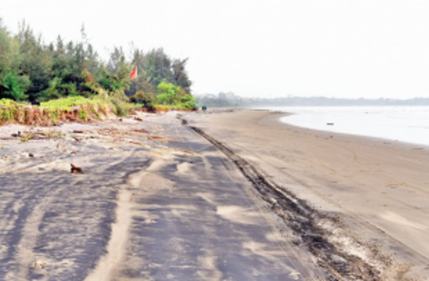
The Survey of India (SoI) Toposheet of 1964 depicts the scenario of the past. A narrow natural sandy beach was present from Miramar up to present day forest nursery, and a built-up river bank further upstream up to the city ferry point. Subsequent human interventions such as sea walls changed the face of a natural river bank. Coastal erosion led to the disappearance of sand. In comparison, a very extensive tongue of sand accumulated around the present children’s park. Rapid accretion of sediment is a recent phenomenon that is in operation over the last 60 years or so. Multi-dated maps, historical documents and satellite images confirm the magnitude of sand accumulation. Presently, the sand body occupies an area of about 49,000 square metres; dense vegetation with tall trees characterises this unique sandy feature. The sediment deposit is narrow in the south, gradually fattens in the middle part, extends to about 190 metres into the river at the central point and veers back towards the bank further upstream. At this point, the sandy shore is found just 8 metres away from the existing promenade wall, opposite the old GMC heritage building. Mangroves are sprouting promptly adjacent to the mouth of the creek. As a consequence, sand almost engulfs the mouth of St Inez Creek, thereby blocking it almost entirely. At this rate of sediment accretion, the sand body will completely enclose the mouth of St Inez Creek, by leaving a small lagoon in front of it. In a worst case scenario, the St Inez Creek may be rendered non-functional in the near future.
Based on the morphological configuration of the sand body, it is obvious that littoral sand drift occurs from south (downstream) towards the north (upstream). In 2007, a rubble wall was built along children’s park beach in the name of erosion on an accreting beach! Around 325 metres of natural bank was transformed into a rubble mound wall. The impact of hard structures on shoreline sediment transport and the eventual disappearance of beach sand are well established in scientific literature. It is obvious that accretion upstream at Campal is occurring at the expense of chronic erosion downstream. At present, the entire strip is devoid of sand. As a consequence, sand has continuously moved upstream, thereby nourishing and enlarging the tongue of sand, virtually blocking the mouth of the creek.
The SoI toposheet of 1964 also reveals that St Inez Creek is a tidally influenced water body with saline water influx observed much beyond the Fire Brigade station, an observation reiterated before. Obviously, saline water fed the creek twice daily probably since historical times. The presence of fish until recently proves that the creek was sufficiently oxygenated. Mangrove stands are still identified far into the city indicating that saline intrusion does take place. However, frenzied modern development has resulted in encroachments, places and the growth of invasive plants at many sites. Utter neglect, lack of management initiatives and unresponsive public attitude has taken a heavy toll on the natural functioning of this heritage saline creek, the tidal influx in particular.
Goa CZMP (draft) 2021 maps have marked this geomorphic feature erroneously. Only a thin strip is shown as a beach when, in fact, the entire area constitutes a densely forested low sand dune. Whereas the formation of a sandy beach within the Mandovi River is an ecological asset for Panjim city, the continuous accretion and the expanding sand body around the mouth of a waterway is a kind of distress for the overall welfare of St Inez Creek. Here, a dilemma arises: (i) The creek has to remain functional for which its mouth has to be free of any hindrances, so as to ensure free tidal influx and discharge of excess rain water, and (ii) The sand body calls for conservation since it is a natural formation and an urban forest of high ecological value, for example, in terms of ecosystem services that a wooded city beach can offer its inhabitants.
With a kind of a piquant situation, how can the issue of sand deposition at the mouth of the creek be addressed? To be noted, mangroves are flourishing at a corner of the small lagoon, across the mouth of the creek. These opportunistic colonisers trap sediment and are known as land builders. Therefore, a scientific coastal management solution by training and re-shaping the tongue of sand is the only viable option. Relocation of mangroves and removal of sand by manual methods are recommended.
The upstream curving tip/portion of the sand body needs to be cut and realigned, so that the existing narrow opening gets significantly wider to allow unrestricted flow of tidal waters into the creek. The sand dug out can be used to create a large dune in-situ or excess sand can be transported to feed and nourish the degraded dunes of Miramar. In no case should the sand be taken away or be dumped into the river.
(Dr Antonio Mascarenhas is a former Scientist, NIO, Goa)