According to recent reports, Maharashtra is the first Indian State to declare mangrove tree species ‘Soneratia alba’ as a symbol to enhance conservation of the salt tolerant vegetation. The proposal from the State mangrove cell to declare Soneratia alba as State mangrove tree was approved by the State Board of Wildlife. The proposal was approved considering the ecological importance of mangroves and the biodiversity it hosts. Last year, the cell recorded a threefold increase in mangrove cover from 2% to 6 % around Mumbai since 2011. Since the State has the popular mango as a dedicated tree, the proposal of coastal mangroves as the second tree is a surprise of sorts. Mangroves do not belong to the category of threatened flora.
Ecosystem services rendered and the crucial role played by mangroves along tropical coastlines is well established. Our field observations across Goa reveal an excessive dispersal of mangroves, occupying large spaces in khazans, used as paddy fields. In a review of coastal zones of India, the Space Applications Centre, Ahmedabad, concludes that in Goa, mangroves with Avecinia as a dominant species, showed a cover of 6.7 sq kms in 1990-1993 that increased to 34.63 sq kms in 2005-2007; this time-series exercise indicates an overall growth of 515% in 15-17 years. As in Maharashtra, a phenomenal increase of mangrove cover in Goa is confirmed.
Low-lying khazans that embrace rice fields of Goa are the victims of rapid landward extension of mangrove forests. Prevailing CRZ laws guarantee their protection as CRZ I, where human interference is forbidden. Here, a piquant situation arises: large spaces on paddy fields are occupied due to excessive mangrove growth, but these trees cannot be removed as they are protected by coastal regulations. A suitable policy for the management of mangroves does not exist. Fertile cultivable land is lost and, as a consequence, traditional farmers are the ultimate losers.
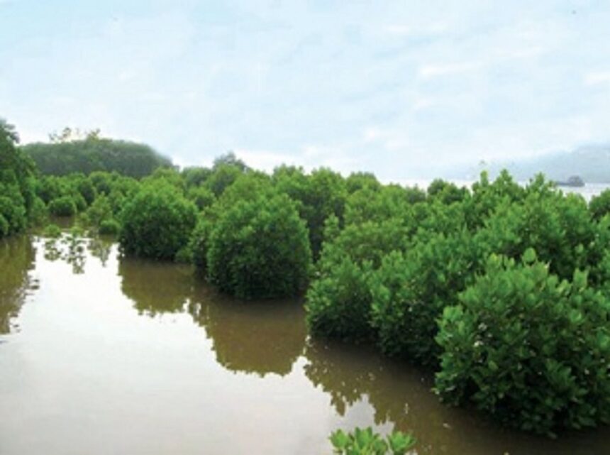
Where are mangroves growing and expanding? For a meaningful understanding of the distribution and evolution of mangrove trees in space and time, a close look at the Survey of India (SoI) topo-sheets of 1964 is needed. A comparison with modern satellite images and maps can reveal their expansion over the last 50 years or so. Consider the following examples where mangroves are flourishing at wrong sites:
(1) At Candolim, upstream of Nerul bridge, the traditional embankments had collapsed at places. River water flooded the khazan. Rising waters transport seeds as a result of which mangroves have invaded the khazans area. A dense mangrove forest occupies an erstwhile paddy field. (2) A similar scenario is observed along the Sinquerim–Candolim river bank. Due to a complete disregard for the well-being of the network of ancient ‘bundhs’ long stretches of kilometres of khazan are occupied by mangroves. (3) A classic example of mangrove invasion of coastal lowlands can found at Patto–Ribandar–Merces–St Cruz region. The SoI maps of 1964 have demarcated the entire area as salt pans where the traditional agro-industry was operational till about a decade, and still observed at isolated sites. The last 50 years have seen a dramatic increase in the lateral expansion of mangroves which have grown into huge trees. In places where there were none in 1964, mangroves have spread up to the new bypass, more than a kilometre from the Mandovi river, and even beyond up to St Cruz and Merces. (4) From Carambolim to Agassaim, the largest ‘khazans’ of Goa, a similar disposition is seen. In particular the Neura–Mandur sector, is being taken over by mangroves. Large parts of low-lying fields and even lagoons are packed with mangroves. (5) The strip from Borim–Rachol to Macazana, the second most prolific khazan of Goa, is witnessing uncontrolled growth of mangrove colonies within khazans. Mangrove seedlings have the capacity to float in moving saline water. These sprouts find their way into the paddy fields where they take root in easily available marshy substrates. Improper management initiatives of ‘bundhs’ is the cause. With time, and being opportunistic colonisers, these saplings develop into luxuriant mangrove forests. It is confirmed that large parts of erstwhile paddy fields now function as mangrove marshes. Agricultural fields of yesteryears have been rendered fallow.
Which ecological settings should mangrove growth be restricted? It is known that mangrove species characterise low energy saline environments with loamy substrates. Intertidal zones along river banks, lagoons and backwaters are the habitats where these trees thrive. Unwarranted construction of concrete defences has affected the survival of mangroves leading to their extinction; built-up banks are devoid of mangroves. Mangroves can act as bio-walls along the inner periphery of river banks and khazans. Saline water bodies ought to be lined by natural fringing mangroves, as their role in the stability of protective embankments is acknowledged globally. Antecedent mangrove marshes marked by prolific, dense and luxuriant mangrove forests on productive tidal flats outside khazans call for conservation efforts from the biodiversity viewpoint.
Mangroves in Goa can be termed as “bona-fide invaders” as they act as opportunistic colonizers of soft soils. This author has debated before that these trees are thriving where they should not grow (paddy fields), but are disappearing from their rightful places where they rightfully belong (river banks). Their proliferation at wrong places needs to be curtailed at all costs, paddy fields and khazans need to be set free of these floral intruders, but instead, plantations must be promoted vigorously as fringing mangroves for the sake of stability of river banks.
(Dr Antonio Mascarenhas is a former Scientist, NIO, Goa)