Yet again the Goa CZMP 2021 is found wanting. After the turmoil that followed the earlier version of the draft CZMP 2018 where entire villages revolted against the coastal plans, it was expected that the new draft would correct the defects. Instead, the new draft is draconian. Surprisingly, we hardly see any activity since the draft is made public. If the 2021 draft is imposed upon, a complete elimination of the sandy coasts of Goa, the dunes in particular, is imminent.
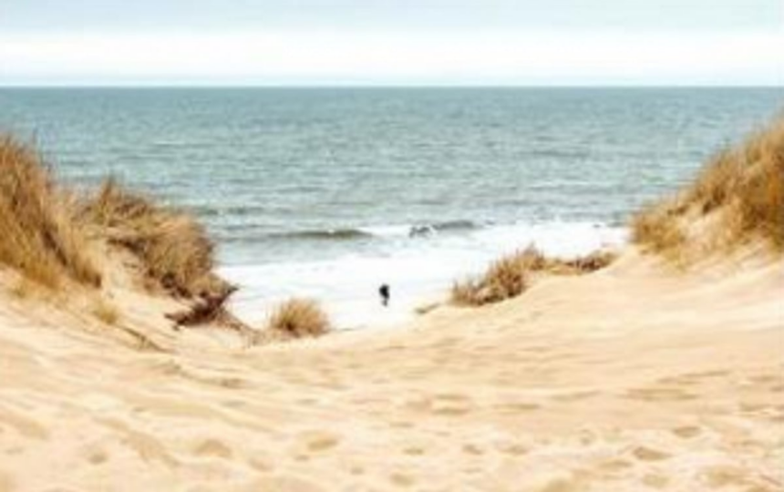
The Survey of India toposheets of 1964 had unequivocally revealed that sandy coasts of Goa are backed by wide stretches of sand dunes, the Salcete coast in particular. Subsequently, dune belts of Goa were researched by NIO scientists since the 1980’s. Wagle (1989) had studied coastal features of Goa using aerial photographs wherein dune belts were mapped in detail. Subsequently, Mascarenhas (1998, 2009) reported field based morphological features and methods to restore degraded dunes. All available maps and data have retold that sandy beaches of Goa are invariably backed by linear active pioneer dunes, stabilised dune fields, and a series of parallel beach ridges. At places, dune complexes of Salcete are more than 350 metres wide with dune peaks of 7-8 metres in height.
Querim has low dunes which are ignored. Arambol, Mandrem, Morjim has long stretches of undulating features, but only a few tiny patches are shown. Calangute, Candolim and Baga sectors, although densely built-up, still has massive dune fields towards Sinquerim, but only few patches are mapped. The entire coast of Salcete, from Cansaulim to Mobor, is supported by majestic linear dune complexes. Cansaulim, Arossim, Utorda, Majorda, Consua up to Betalbatim are marked by dunes of variable heights, but these landscapes are shown in patches on the plan. South of Colva, sand dunes are somewhat intact, but are ignored. The most appalling case is that of Sernabatim; although the beach road passes over 7-metre high sand dunes, these features are not mapped in the CZMP; such a mapping cannot be accepted. The same applies to Benaulim, Varca, Cavelossim where continuous dunes are identified. Cavelossim end point is a large dune field, but the plan only shows small discontinuous patches. In the south, prominent narrow dunes of Agonda and specially Galgibaga do not feature at all. In short, (a) sand dunes of varying heights characterise the entire sandy coast of Goa, (b) dune flora (creepers, bushes) is almost ubiquitous, (c) vegetation is uprooted at places, (d) dunes are degraded at places due to excessive footfalls. Yet, the CZMP has ignored all such work and reports by NIO; the bibliography listed in the report is biased.
The most outrageous aspect of the new CZMP 2021 is that: (1) Miramar beach is classified as CRZ II. This proposal is grossly absurd and entirely unscientific, and would mean that anything and everything can be done at/to Miramar. Any schoolboy will confirm that Miramar beach up to Caranzalem is marked by low to medium sand dunes with dense vegetation; tall dunes are visible from the road. This particular issue of dune morphology was discussed at a meeting of CCP presided by the Commissioner. It was accepted that Miramar is a low dune coast and would be marked as such. (2) Rajbagh beach and Patnem coasts are mysteriously categorised as CRZ II; urbanisation of these rural areas is now certain. (3) Palolem was no doubt crowded with illegal structures, but the southern part was intact; entire strip now comes under CRZ II. Ground realities in no way justify such villages as CRZ II.
Conservation of natural ecosystems and rejuvenation of damaged landscape is lacking in CZMP: (1) Conservation of dune fields: The linear sand dune belts of Goa need to function as Nature’s first line of defence and hence call for preservation. (2) Rejuvenation of degraded dunes: Dune sections found in various stages of despair due to indiscriminate human actions must be brought back to life with available scientific methods. (3) Restitution of lost morphological features: (4) Flattened dunes: Excessive trampling due to footfalls at beach entry points are sites that call for urgent restoration measures. (5) Deracinated vegetation: Plantation of creepers and bushes all along the frontal mounds will contribute towards stable and healthy dunes. (6) Deployment of sand fences: Erecting eco-friendly wooden hedges is an easy way to trap mobile sand, a successful method tried at Miramar in 2007 where dunes created artificially are functioning naturally. (7) Beach nourishment: Sustaining beaches and dunes with imported sand is a modern scientific strategy for restoring the eroded of sandy areas. (8) Sand dune parks: Five dune fields at Mandrem, Morjim, Galgibaga, Agonda and Miramar are proposed as dune parks, a first-ever effort in India.
Considering the above, it would appear that mapping of sand dunes of Goa has been done by novices rather than expert coastal scientists. Miramar beach as CRZ II cannot be accepted. Large dune fields from almost entire Salcete coast are ignored. As such, this plan is highly deficient and, to a point, a fraud of sorts. Unquestionably, the CZMP 2021 has to be reconsidered. A well envisioned CZMP demands wide sandy coasts, backed by extensive, stately and stable sand dune fields, capped by dense luxuriant vegetation, with creepers on pioneer dunes, bushes and shrubs on hind dunes, with a wooded backshore.
(Dr Antonio Mascarenhas is a former Scientist, NIO, Goa)