Team Herald
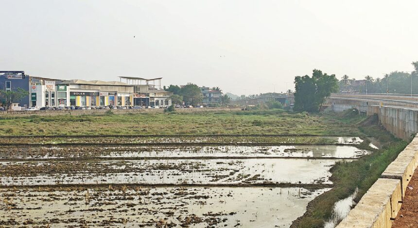
MARGAO: The commissioning of the missing link of the Western Bypass from the SGPDA wholesale fish market to Benaulim has sparked serious concerns among residents and experts regarding its environmental impact and safety. Built partially on stilts and partially on a mud embankment, the bypass runs through the floodplains of the River Sal, a region regularly inundated during monsoons.

Former MLA Radharao Gracias highlighted parallels to the Loutolim bypass, where a similar embankment collapsed and had to be rebuilt on stilts. “The entire stretch is built in the soggy floodplain of the River Sal, which gets inundated during the monsoons. The sides of the embankment are pitched with rubble stones, but that may not be enough to prevent collapse. There’s a likelihood of the approach roads, particularly in Benaulim, being flooded, as this area is regularly inundated. I do not know whether these aspects were considered in designing the road,” he said.
Echoing these concerns, Bharat Kamat said, “This appears to be a disaster waiting to happen. Building an embankment in a floodplain prone to monsoon inundation without sufficient consideration of hydrological factors is risky. The collapse at Loutolim is a clear warning. Ignoring these aspects could lead to flooding, road failure, and displacement of local communities.”
Orlando C S Dias, a structural engineer, said, “I live on the Navelim side of Margao, and the bypass helps avoid congested traffic. However, the construction near the Benaulim junction and Kharebandh rivulet raises concerns. During monsoons, mud roads across khazan lands are inherently vulnerable to sinking or sagging. The stretch from the Benaulim junction till the Kharebandh rivulet will likely face collapses during heavy rainfall.”
Benaulim resident Rudolf Barreto linked the bypass’s rushed construction to corporate interests. “This project was stuck for years until they needed a carriageway for coal. It was completed superfast, ignoring public pleas. The embankments will harm Benaulim and upstream villages. I foresee frequent closures due to flooding and embankment failures,” he warned.
Benaulim MLA Venzy Viegas said repeated calls for action have gone unheard. “We’ve raised this issue in the Assembly and during instances of flooding at Tolleaband. Two inspections have been conducted, but no measures have been implemented yet,” he stated.
Central expert R.K. Pandey was tasked by Union Surface Transport Minister Nitin Gadkari to study the flood-prone zones after a petition by Goa Forward Party chief Vijai Sardesai, who had demanded a stilt-based design through the Tolleaband water body in Benaulim. While Pandey rejected the stilt proposal, he recommended comprehensive drainage measures.
Pandey’s report emphasized the need for de-silting and dredging the River Sal to improve its discharge capacity. It also highlighted the inadequacy of the drainage infrastructure on the Varca road, which has only two culverts, compared to the bypass’s 10 culverts over a similar stretch.
“The Varca road’s two culverts are insufficient for the catchment’s water flow. The bypass, by contrast, has 10 culverts. Additional culverts or larger ones are needed to prevent water stagnation in the triangular area formed by the bypass, Khareband road, and Varca road,” Pandey noted in his report.
Flooding during monsoons is routine in the River Sal floodplain. Water from the triangular area must cross the Varca road to reach the River Sal, but the existing culverts lack the capacity to handle the flow. Residents fear that without comprehensive drainage solutions, the embankments could lead to frequent road closures, structural failures, and displacement of communities.
Pandey’s recommendations included increasing the number of culverts on the Varca road, de-silting the River Sal to improve discharge capacity, and implementing a comprehensive drainage plan. However, sources indicate that while the report has been forwarded to relevant departments, no substantial action has been taken.
Orlando Dias also drew attention to the lessons learned from past mistakes, saying, “The late Chartered Civil Engineer Urbano Lobo often explained the challenges of mud embankments in khazan lands. The construction here seems to ignore these fundamentals, which could lead to serious consequences.”
Pandey also observed that the bypass alignment passes through the floodplains of the River Sal, which serves as the outlet for the entire catchment area. However, during high tide, backwater flow extends to several kilometres. As the catchment area is low-lying, inundation during monsoons is almost inevitable without addressing outfall issues comprehensively.