The people of Benaulim are pulling their hair out as they are running out of options in convincing the State government that building the proposed western bypass through their village on embankments will cause irreparable damage and destroy fields, biodiversity, human settlement and much more.
The locals have filed petitions in the court, met all the authorities concerned, prayed together and even had their children come forward to voice out their opposition to what the government is planning on doing.
It has been their long-standing demand for over five years now, that the Benaulim stretch of the western bypass should be built on stilts and not as embankments as has been proposed. While the government has agreed to build other stretches of the bypass on stilts such as through the neighbouring area of Seraulim and Mungul, it has refused to change its stance when it comes to Benaulim. Unfortunately for the locals, rulings from the National Green Tribunal (NGT) and the High Court (HC) were not in their favour, which has only emboldened the government to go forward with the work on the bypass.
Presently, the locals fear that without any court order stopping the work and the government’s reluctance to issue an order to halt the work, work on the bypass will begin once the monsoon season subsides.
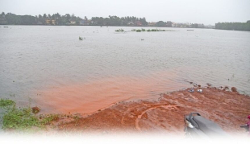
Their last hope is based on the recent inspection report that was carried out by the Water Resources Department (WRD), which had inspected the flooded Tolleabandh area along with the Disaster Management Team in the first week of July when it was raining heavily.
For perspective Tolleabandh is part of the area through which the western bypass will be built on embankments.
In this flood risk assessment report that was submitted by the WRD Assistant Engineer (AE) Sainath M Jamakhandi, the department has categorically stated that if the western bypass is built on embankments on this stretch, it would lead to not just flooding but be disastrous to life, livelihood and property.
More importantly, WRD pointed out that the floods that had occurred in Tolleabandh and surrounding areas occurred when the western bypass had not yet been constructed and thus it is likely that the intensity of the floods would be far greater if the low-lying areas are filled for the construction of the embankments.
What the wrd report stated
In the report submitted on July 8, 2022, the WRD referred to the site inspection that was carried out on July 5, 2022 between 11 am to 1.30 pm.
In that week, a red alert had been issued by the Indian Meteorological Department (IMD), which had forecast that there would be extremely heavy rainfall till July 10, due to which a decision had been taken by the Disaster Management Team to inspect Tolleabandh.
On that day, as per the notes of the WRD Executive Engineer (EE), “the flooding of the flood plains of River Sal was not seen ever before in the last five years”.
Besides the WRD Assistant Engineer (AE) and Executive Engineer (EE), their Junior Engineer (JE) was also present for the inspection. Officials from the District Collectors office, the PWD AE and JE along with the Benaulim MLA Venzy Viegas, the villagers, the farmers and panch members of Benaulim and Seraulim village panchayats were present.
“It has been observed that, there is flooding along the low-lying areas from wholesale fish market (Mungul) to Mercaddo in Karle Villa at Khareband. The inspection team visited the various locations in the flood-prone zone. It was observed that the kachha service road constructed for western bypass was completely submerged and flooded at 12.30 pm on 5th July 2022,” read an excerpt of the report.
“The houses in the vicinity of the Tollebandh were also flooded. A total of 22 houses along the bandh and neighbouring houses were affected by the flood waters. Further the MLA and WRD Officials took the boat in the flooded area of the western bypass and found that the depth of the water was almost 1.5 mtr to 2 mtr depth,” said WRD AE Jamakhandi.
The report further highlighted how the heavy continuous rain was also causing havoc and that this was all happening three hours before the maximum high tide level which would have occurred around 3 pm on that day.
When it was maximum high tide, the WRD report confirmed that the flood water level had increased and had started to flow over the road. This has been the constant argument that was put forward by the locals but the government had turned a blind eye to their concerns until the WRD’s own report had backed what the locals had been saying for years now.
The AE also pointed out that as per weather forecasts, heavy rain was expected to continue later on as well.
“The flood water is causing inundation of agriculture fields away from the river in Seraulim village thus destroying their crops. The flood water also reaches up to Auxilium School at Benaulim. All the low lying catchment areas within 500 m of the river Sal are filled to the brim due to the continuous heavy rainfall and the high tide was still to come, all this flooding is when the western bypass is still not constructed on embankment,” WRD added further.
“Seeing the conditions and the increasing incessant changing rainfall patterns, it can be concluded that there is a high possibility of flood waters to rise at a magnified level in the future if the western bypass is constructed on embankment filling for the remaining portion from Railway line till the Khareband-Varca road.,” said the AE.
“The possibility of disaster to life, livelihood and property of the local inhabitants in future needs to be considered in going ahead with the construction of the western bypass on embankment in the said reach,” the AE concluded.
WRD also attached the report that had been prepared by its EE who is in charge of River Sal.
“Due to coincidence of high tide and the heavy rain showers, water entered into many houses existing on the bandh and other areas with furthermore increased depth of water.
Due to heavy rain showers, the existing road network was inundated at many places causing stoppage of traffic movement and very complex hydraulics was observed during the high tide. Flooding of houses were also observed towards the Margao city in Comba at Vittal Mandir area,” said the EE.
“The above situation was in the absence of western bypass and it may become more complex and may result in worse conditions after the completion of the western bypass. Therefore it is recommended to have the model study with an expert hydrologist to avoid the worst circumstances that may occur in the future on account of development along the bank of the River Sal,” the EE concluded.
As of now the matter is before the State government completes that survey by a hydrologist. The MLA stated that he had asked the PWD Minister to slow down the pace of works until this hydrologist survey was out and that the WRD report should be taken into consideration as well by the government as well as the courts.
WRD had issued a warning in 2019 too
In December 2019, WRD had submitted another inspection report that had strongly recommended the need for the PWD to work on the possibility of minimising the filling area. “As the construction of road includes the filling of low-lying areas, the possibilities of minimising the filling area needs to be worked out by the PWD department by proposing the road on stilt as the alternate case by considering the long term damage to the agriculture land and biodiversity ,” said WRD in that report.
WRD had also recommended that a proper drainage system needs to be provided to protect the area from flooding during the monsoon. It had even stated that the proposed western bypass road is very close to River Sal and therefore there is scope for damaging the banks/ bundh/ drains connecting the river Sal during the construction stage. It had called for frequent joint monitoring to reinstate the damaged sites till the final stage of construction.
It had also reiterated the need to explore alternatives as the many water bodies were going to be damaged permanently and that the agricultural activities have to continue as well.
Even the TCP had raised objections in 2019
The Town and Country Planning (TCP) Department had also submitted an inspection report in 2019 where it had emphasised on the requirement of a detailed study to be carried out by a competent authority. It had justified this recommendation by pointing to the the flooding in the area on account that the said stretch of land is low-lying agriculture area which also acts as catchment area during monsoon
While it also showed that some of the survey numbers in the affected area have been classified as river and nullah/ponds as per the Regional Plan 2021 and that the major portion of the land is under cultivation zone and that there is a paddy field zone too.