SHASHWAT GUPTA RAY
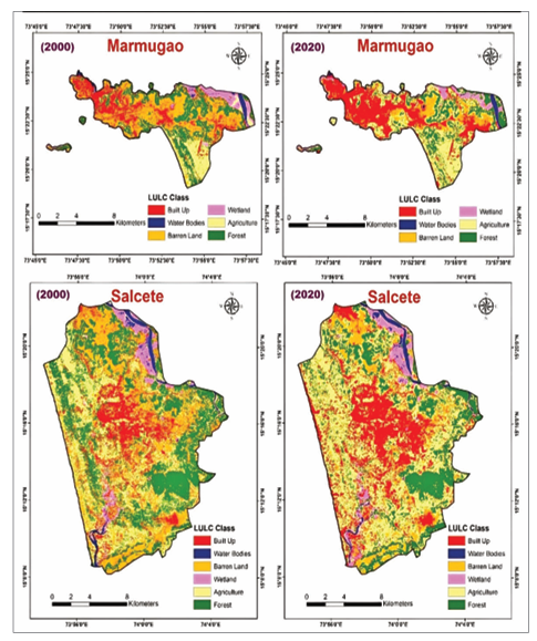
A spurt in human activity in the eco-sensi tive talukas of South Goa — Mormugao, Salcete, Que pem, and Canacona — has led to a sharp expansion of built-up areas, from 83.13 sq km in 2000 to 133.22 sq km in 2020, marking a 60.25% rise, primarily in Mormugao and Salcete ta lukas, a study by research ers at Goa University has shown. The researchers an alysed satellite data across the four talukas. The data was derived using a geospatial model to quantify human-driv en changes in South Goa’s coastal landscapes, offer ing vital tools for sustain able development. The model was devised by Dr Mahender Kotha, former senior professor at Goa University’s School of Earth, Ocean, and At mospheric Sciences (SEOAS), and Dr Ritwik Nigam. The findings of the study have been pub lished in the Environ ment Development and Sustainability journal. “The research intro duces an innovative anthropogeomorphic index. This holistic framework measures the cumulative effects of construction, tour ism infrastructure, transport networks, and land reclamation on natural landforms, elevation bands, and land-use categories along the Arabian Sea coast,” Dr Kotha told O Heraldo. Key Insights on Land TransformationThe model identi fies hotspots of intense concretisation, where agricultural land declined by 8.1%, alongside reductions in forests and water bodies, while soil erosion rates emerged as moder ately high state-wide and at peak levels in the study area. These shifts highlight how rapid urbanisation and tourism can destabilise coasts, fragment habitats, and heighten vul nerability to flooding, erosion, heat, and water-logging. As per the study’s findings, soil erosion in Mormugao and Salcete is overall moderately high, but the highest levels are seen in coastal areas. Mormugao tops the list as it is located on a lateritic headland, while Salcete has gentle, low-lying Zuari river floodplains formed by unconsolidated particles. Both talukas are prone to erosion, but growing urbanisa tion has had a very significant impact on relatively uncon solidated land. “While the study has identified the problems, it also en ables proactive solutions: hotspots signal opportunities to integrate the index into planning, enforce setbacks in low-elevation zones, limit hard structures, and prioritise dune, wetland, and drainage restoration,” the senior re searcher said. Building Resilience for Ecosystems and Communities By reducing permeable surfaces and natural buffers such as dunes and wetlands, anthropogenic pressures disrupt biodiversity and strain livelihoods dependent on tourism and fisheries. “However, nature-based solutions—such as enhanced green infrastructure—can restore defences, safeguard wa ter systems, and mitigate health risks such as disease and displacement,” Dr Kotha added. Dr Nigam emphasised the index’s versatility for appli cation in any region. “Planners can now diagnose stress, evaluate projects against impact thresholds, and foster ev idence-based management to balance growth with coast al vitality. This forward-looking approach not only raises awareness of human impacts but also guides Goa toward resilient, thriving shorelines for future generations.