SHASHWAT GUPTA RAY
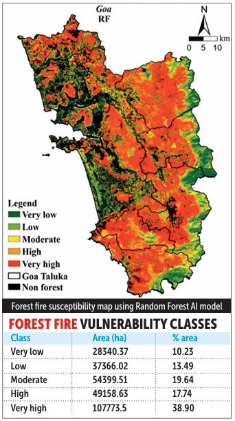
Three years ago, wildfires in Goa de stroyed large swathes of forest and vegeta tion, marking one of the State’s most significant ecological incidents. But the threat is far from over, as a study by the Indian Council of Agricultural Research (ICAR)-Central Coastal Agricultural Re search Institute (CCARI) shows that 45 per cent of Goa’s forest area is prone to wildfires, largely due to increasing human ac tivity and climate change. “Our study focuses on identifying and mapping forest areas in Goa that are vulnerable to forest fires. Using advanced tools like remote sens ing data, geographic in formation systems (GIS), and machine learning, we developed detailed maps showing zones with dif ferent levels of fire risk, from low to very high susceptibility,” Senior Scientist (Agroforest ry), Natural Resource Management Section, ICAR-CCARI, Dr Uthappa A R, told O Heraldo.

According to Dr Uthappa, Goa’s forests were traditionally less prone to fires due to high rainfall and moist conditions. “However, recent climatic changes, such as rising tem peratures, erratic rainfall, prolonged dry periods, along with increased human activities, have significantly in creased fire incidents. Hence, the study was undertaken to identify high-risk zones in advance for better planning and prevention strategies. This was especially important after recent fire events, where large forest areas were affected,” he said. The study, published in the Journal of Environmental Management, has been co-authored by Bappa Das, Anurag Raizada and others. The research combined field observations, remote sens ing, GIS, and advanced modelling techniques — including satellite data analysis (MODIS-NDVI, MODIS-LST, DEM, forest type), GIS-based mapping of fire-related variables (distance to settlements, distance to roads), the Analyti cal Hierarchy Process (AHP) for assigning weights to con ditioning factors, and machine learning models such as Random Forest (RF), Support Vector Machine (SVM), and XGBoost. Field surveys were conducted for calibration and valida tion of the models using fire and non-fire locations. Nine key factors were considered, including slope, aspect, for est type, vegetation type, temperature, NDVI, topographic wetness index, and proximity to roads and settlements. An assessment of fire occurrence in Goa revealed that, over a five-year period from 2017 to January 2023, an area of 521.29 hectares was affected by fire, with the largest ex tent recorded in 2019-20. “The study revealed several critical insights. A large pro portion of Goa’s forests are now highly vulnerable to fires. About 44 per cent of the forest area falls under very high fire susceptibility, followed by significant high and moder ate risk zones. Human proximity (roads and settlements) is a major trigger for fires. Dry conditions after the monsoon, along with rising temperatures, increase fire risk. Forest type, slope, and vegetation condition (NDVI) strongly in fluence fire occurrence,” the senior scientist said. He added that the findings have important implications for policy and management. “It enables early warning systems and targeted fire pre vention, helps the Forest Department prioritise high-risk zones for monitoring and intervention, provides a scientif ic basis for resource allocation and disaster preparedness, and highlights the need to integrate technology (AI and GIS) into forest governance. Overall, the study shifts fire management from reactive to proactive planning,” he said. He also called for measures to ensure that economic de velopment proceeds without compromising forest ecosys tems and biodiversity (see box 2).